




Teledyne FLIR Releases Reimagined Raven Security Site Planning Web Tool
17/10/2023 FLIR Systems UK (*Teledyne FLIR)
Indispensable Workflow Application Features the Latest Teledyne FLIR Cameras with an Improved User Experience and Robust Collaboration Capabilities
Teledyne FLIR, part of Teledyne Technologies Incorporated, today introduced an enhanced version of Raven, the latest iteration of its professional security site planning web tool. To provide integrators with improved functionality, Raven includes real-time collaboration capabilities between Raven users along with the introduction of more Teledyne product solutions.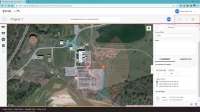
“The reimagined Raven web tool offers a comprehensive suite of controls to simulate mounting height, rotation, range, and image detection to ensure accurate placement and performance of Teledyne FLIR security and ITS hardware in real-world conditions,” said Matt Strautman, global director of business development, Teledyne FLIR. “Furthermore, Raven makes collaboration central to the experience, including the option for one user to share a report with another Raven user to work on the plan in real-time, affording quick and easy collaboration with partners, customers, and colleagues, helping reduce revision time while improving accuracy.”
Using the latest satellite imagery via Google Maps, Raven empowers users to place any number of FLIR cameras, including the latest releases such as the FLIR FC Series AI and the FLIR FH Series ID multispectral fixed cameras, in highly accurate, coordinate-controlled locations anywhere on Earth.
The new version of Raven is built to help site planners quickly choose the right configuration of cameras to secure a given location, including the option to test various configurations to ensure proper coverage and camera placement. The enhanced software also saves time and money by enabling collaborators to right-size for the available budget all the way through to the site implementation stage. More specifically, the visualization of camera coverage provides peace of mind for intelligent implementation completed faster and with less risk.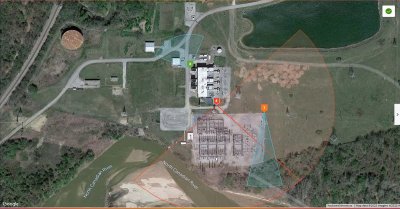
Raven makes it easy for site planners to switch between camera models before or after the layout is built and then use color-coded detection zones to quickly differentiate between radar, thermal, and visible camera placements. The application also provides an improved distance calculator with the ability to grab and stretch a given camera’s range directly on the map. Additional features include the ability to add site plan notes at the point of camera placement and when generating the final report.
Once the user has created a plan, they can save it to their projects folder, and then create a PDF output containing the camera specifics, GPS coordinates for each camera, and the satellite plan overview map. Users can also effectively build a quote and then pull it directly from Raven to share with colleagues, clients, and partners for streamlined input and approval.
To learn more or to purchase the Raven site planning tool, visit https://www.flir.com/products/raven/?segment=solutions.
 Print this article
For more information, please contact:
FLIR Systems UK (*Teledyne FLIR)
2 Kings Hill Avenue
Kings Hill
West Malling
Kent
ME19 4AQ
Tel: +44 (0)1732 220011
Email: sales@flir.uk.com
Web: https://www.flir.com
Share article:

Process and Control Today are not responsible for the content of submitted or externally produced articles and images. Click here to email us about any errors or omissions contained within this article.